The geology of Ibbenbüren
 During the Late
Carboniferous large parts of Northwest and Central Europe consisted of
lowlands covered with swamps. In these swamps peat was formed.
Peatforming in lowlands only occurs when the increase of the peat
layers is keeping pace with the descent of the soil. From time to
time this equilibrium was disturbed and the swamps were flooded. The
swamp drowned and got covered with a layer of erosional material (sand
and clay). As a consequence of the pressure the peat layers settled
down. After some time the depression got filled up, the descent of the
soil slowed down or the sea level was lowering, and at the clay layer a
new swamp came into existence.
During the Late
Carboniferous large parts of Northwest and Central Europe consisted of
lowlands covered with swamps. In these swamps peat was formed.
Peatforming in lowlands only occurs when the increase of the peat
layers is keeping pace with the descent of the soil. From time to
time this equilibrium was disturbed and the swamps were flooded. The
swamp drowned and got covered with a layer of erosional material (sand
and clay). As a consequence of the pressure the peat layers settled
down. After some time the depression got filled up, the descent of the
soil slowed down or the sea level was lowering, and at the clay layer a
new swamp came into existence.
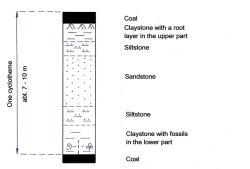 In the deposits of
Ibbenbüren this cycle (also called cyclotheme, click on the
picture on the right) has repeated itself more than a hundred times.
Only in a few cases this has resulted in a seam that is worth
extracting coal. On top of each coal layer a fine-grained layer with
plant fossils can be found. Above that a (mostly thick) layer of
sandstone is situated. Below the coal seam there is always the
root layer, in which many root bearers of the clubmoss and horsetail
trees have been fossilized.
In the deposits of
Ibbenbüren this cycle (also called cyclotheme, click on the
picture on the right) has repeated itself more than a hundred times.
Only in a few cases this has resulted in a seam that is worth
extracting coal. On top of each coal layer a fine-grained layer with
plant fossils can be found. Above that a (mostly thick) layer of
sandstone is situated. Below the coal seam there is always the
root layer, in which many root bearers of the clubmoss and horsetail
trees have been fossilized.
As the original peat layer was covered up by a increasing thick deposit of sediment, pressure and temperature were also increasing. As a consequence the peat converted at first to brown coal and then to coal. This process, during which the content of pure carbon is more and more increasing, depends mainly on the temperature of the rock. The pressure is not important: it has only significance in a very early stage of the dehydration of the peat. The last phase of this process is the anthracite level in which the coal consists of more than 96% of pure carbon. The coal of Ibbenbüren and also that of the nearby Piesberg near Osnabrück has reached the anthracite stage, this in contrast with other coal occurrences, such as the Ruhr Region or South Limburg (NL).
There are two theories aimed to explain this high grade of carbonizing. The first one, which was suggested in the fifties, states that during the Late Cretaceous a magma intrusion occurred near Bramsche up to a depth of 5 km. There it stopped and the magma solidified. This 'pluton' is called the Massif of Bramsche and it ranges over about 150 km between the rivers Ems and Weser. The other theory, published in the beginning of this millennium, states that the coal layers of Ibbenbüren and the Piesberg have been situated at a depth of more than 5 km in the earthcrust. The high grade a carbonizing is thought to have been the consequence of the high temperatures down there.
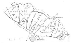
 During the Late Cretaceous the
carboniferous sediments returned to the surface. In this process in the
crust the Piesberg was pressed upward as a hump. In the region of
Ibbenbüren, however, a floe of about 15 to 6 km broke loose and came
upward. This plate has also broken into pieces. In the western and in
the eastern regions are high parts, the Dickenberg and the Schafberg.
In the middle is a lower part, called the Bockradener Graben (click on
the picture on the left).
During the Late Cretaceous the
carboniferous sediments returned to the surface. In this process in the
crust the Piesberg was pressed upward as a hump. In the region of
Ibbenbüren, however, a floe of about 15 to 6 km broke loose and came
upward. This plate has also broken into pieces. In the western and in
the eastern regions are high parts, the Dickenberg and the Schafberg.
In the middle is a lower part, called the Bockradener Graben (click on
the picture on the left).
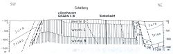
The layers consist of sediments from the Westfalian B, C and D and they have a thickness of at least 2 km. Nowadays all coal comes from seams of the Westfalian B (picture on the right). The thickness of the seams varies between 2 cm and 2 m. As said before only a limited number of coal seams is suitable for extraction. The portion of the coal seams is only 3% of the total thickness of the rock layers.
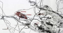
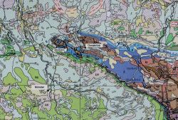 The geological map on the
right pictures the place of the carboniferous outcrops of Ibbenbüren
and the Piesberg in the middle of Mesozoic and Kenozoic layers.
The geological map on the
right pictures the place of the carboniferous outcrops of Ibbenbüren
and the Piesberg in the middle of Mesozoic and Kenozoic layers.